Professional Topographical Survey Services
admin
December 19, 2024

Geographic Information Systems (GIS) have emerged as a transformative technology, enabling organizations and governments to address some of the most pressing global challenges. From climate change and urban planning to public health and disaster response, GIS provides critical insights and solutions that enhance decision-making and foster sustainable development.
Climate change poses a significant threat to ecosystems, economies, and communities worldwide. GIS plays a crucial role in climate modeling, helping scientists visualize climate patterns and assess vulnerabilities. By analyzing spatial data, decision-makers can identify areas at risk of flooding, drought, or other climate-related impacts. This information is vital for developing effective adaptation strategies, such as designing resilient infrastructure and implementing conservation efforts.
As urban populations continue to grow, cities face increasing pressure on resources and infrastructure. GIS facilitates smarter urban planning by providing data-driven insights into land use, transportation, and public services. Planners can visualize population density, traffic patterns, and environmental impacts to create more efficient and sustainable urban environments. For instance, GIS can help identify optimal locations for green spaces or public transit routes, enhancing the quality of life for residents.
The COVID-19 pandemic highlighted the importance of spatial data in public health response. GIS enables health organizations to track disease outbreaks, analyze transmission patterns, and allocate resources effectively. By mapping healthcare facilities and demographic data, public health officials can identify underserved areas and target interventions more efficiently. Furthermore, GIS supports vaccination campaigns by optimizing distribution routes based on population density and accessibility.
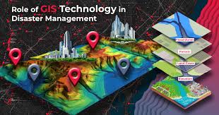
Natural disasters such as hurricanes, earthquakes, and wildfires pose significant risks to communities. GIS enhances disaster preparedness and response by providing real-time data on hazards and vulnerabilities. Emergency responders can use GIS to map affected areas, assess damage, and coordinate relief efforts. For example, during a hurricane evacuation, GIS can help identify safe routes and shelters based on current conditions.
Looking towards the future, innovations in GIS technology are set to drive further advancements:

As global challenges become increasingly complex, the significance of GIS in providing actionable insights is undeniable. At Ortho Map Solutions, we harness the power of spatial data to deliver innovative solutions tailored to meet the needs of our clients across various sectors. Our commitment to leveraging these innovations positions us as a key player in driving meaningful change in an interconnected world, ensuring that communities are better equipped for the future.
Subscribe to our newsletter for exclusive insights into how cutting-edge geospatial solutions are driving innovation and transforming industries.